
How does indoor GPS work?
I'm wondering how does indoor GPS work? I'm reading the news that Apple has taken over the control of WiFiSLAM - a startup that offered GPS inside the buildings using only Wi-Fi signals available inside buildings. So it's obvious that Apple's next iPhone will offer navigation inside buildings and malls. Now it's no wonder that the GPS signal becomes very weak after penetrating through the concrete and most of the times, it's impossible to get GPS satellite to hook on to your smartphone or tablet inside buildings. If I'm not mistaken, the GPS signal is basically a 50w signal that has to travel about 20200 Km before reaching to your cellphone. Now when you're inside tall buildings, the signal can't penetrate the concrete which results into the failure of the global positioning system.
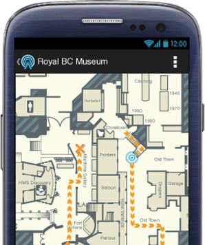
After searching on Google, I found out that the indoor GPS system is actually called as IPS aka Indoor Positioning System and it seems to use some different technique. The IPS uses wireless hotspots and the relative signal strength at various locations inside buildings to form a plot of the floor. In fact, Google Maps (Android App) began offering similar feature several months ago - allowing people to see the indoor floor plans at shopping malls and big restaurants. Chip giant, Broadcom has launched chip BCM4752 that supports indoor GPS with wireless, bluetooth and NFC; and I believe has already found a way inside smartphones and tablets.
Google's using wi-fi hotspots to create indoor maps while Nokia, which developed even higher precision maps used bluetooth to do the same. But the fact is that none of these solutions are accurate. The chips are synched with other sensors inside the smartphone - viz. accelerometer and gyroscope which can track the distance you traveled inside the building, the turns you took and the relative wireless strength you have in all the location to create indoor map of the floor.
I really wonder how do these systems work? If anyone's got more insight into the working of IPS aka indoor GPS, please enlighten all of us. I believe IPS holds a lot of potential (much more than what you can have with GPS). Anyway, the next iPhone is going to bring it for sure.