
IRNSS 1A - India's First Navigational Satellite Is Ready For July 01 Take-Off
@thebigk
•
Oct 26, 2024
Oct 26, 2024
1.5K
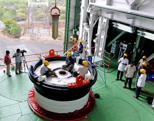
India's space invasion continues with the upcoming launch of IRNSS 1A - Indian Regional Navigation Satellite System. The satellite is getting final touch-ups & checks from ISRO's engineers at the Satish Dhawan Space Center (SDHC) at Sriharikota. The satellite is scheduled to take off on Jul 01, 2013 at 23:41 hrs (IST) . According to ISRO's official website, global checks are currently in progress and the 72 hour countdown will begin soon. The satellite was originally scheduled to launch on June 12; however a technical anomaly required the launch to be delayed till 1st July.
The IRNSS is an independent regional navigational satellite being made in India. It's been designed for providing accurate position information service to Indians as well as region extending up to 1500 kilometers from India's boundary. The satellite will offer two types of services : SPS aka Standard Positioning Service for all the users and Restricted Service (RS) - an encrypted service available only to those who've been authorised. The IRNSS will be accurate to ~20 meters in the primary service area.
The IRNSS will be useful in terrestrial, arial and marine navigation, disaster management, vehicle tracking and fleet management. It will also integrate with mobile phones for navigation and offer precise timing, mapping and geodetic data.
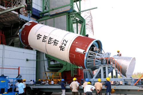
The XL version of PSLV - C22 (Polar Satellite Launch Vehicle), in its 24th flight will be responsible for taking the satellite, with a payload of 1425 Kg, to its desired altitude in the space. The launch will take place from First Launch Pad (FLP) of Satish Dhawan Space Centre.
IRNSS-1A is equipped with 2 types of payloads viz. the navigation payload and ranging payload. The navigation payload will transmit signals in the L5 band (1176 MHz) and S band (2492.028 MHz). A Rubidium atomic clock is a part of the navigation payload of the satellite. On the other hand, the raging payload of the satellite comprises of C-Band transponder which facilitates accurate determination of the range of the satellite.
We wish the entire ISRO team all the best for the successful launch. We'll of course be following the updates.
Via: #-Link-Snipped-#
The IRNSS is an independent regional navigational satellite being made in India. It's been designed for providing accurate position information service to Indians as well as region extending up to 1500 kilometers from India's boundary. The satellite will offer two types of services : SPS aka Standard Positioning Service for all the users and Restricted Service (RS) - an encrypted service available only to those who've been authorised. The IRNSS will be accurate to ~20 meters in the primary service area.
The IRNSS will be useful in terrestrial, arial and marine navigation, disaster management, vehicle tracking and fleet management. It will also integrate with mobile phones for navigation and offer precise timing, mapping and geodetic data.
The XL version of PSLV - C22 (Polar Satellite Launch Vehicle), in its 24th flight will be responsible for taking the satellite, with a payload of 1425 Kg, to its desired altitude in the space. The launch will take place from First Launch Pad (FLP) of Satish Dhawan Space Centre.
IRNSS-1A is equipped with 2 types of payloads viz. the navigation payload and ranging payload. The navigation payload will transmit signals in the L5 band (1176 MHz) and S band (2492.028 MHz). A Rubidium atomic clock is a part of the navigation payload of the satellite. On the other hand, the raging payload of the satellite comprises of C-Band transponder which facilitates accurate determination of the range of the satellite.
We wish the entire ISRO team all the best for the successful launch. We'll of course be following the updates.
Via: #-Link-Snipped-#