
Norwegian Researchers Employ Drones To Track Hidden Oil Reserves
@ambarish-PQyoXg
•
Oct 26, 2024
Oct 26, 2024
1.5K
The potential that Unmanned Aerial Systems (UAS) hold for the future is HUGE, and a glimpse of its gigantism was displayed by Norwegian Geologists as they employ autonomous drones to collect data for developing 3D maps, based on which they plan to track down the oil reserves at land and at sea. Virtual Outcrop Geology members from the Center for Integrated Petroleum Research (a collaborative effort between the University of Bergen and Uni Research) have put into use an octo-copter equipped with all possible sensors including infrared sensors, LIDAR scanners, Hi-Def cameras among others, in order to map down the Norwegian landscape from above.
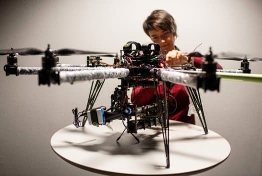
Earlier, the team sought to achieve this purpose by sending out teams equipped with ground based laser scanners and other devices that’d be necessary to document digital maps of the territory from ground. But with Norway’s uneven geography, implementing this mapping method was next to impossible. And so the team had to lease helicopters at a high price to achieve the purpose. Now, with the new drones in play, the same aerial tasks were carried out easily and cheaply (not to forget the huge amount of time saved in the process)- like instantly scaling high elevations and reaching other inaccessible areas to create 3D terrain maps that when incorporated with data obtained from the geological and seismological studies to generate 3D pictures of Earth’s crust. Now these 3D images of the earth’s crust can point researchers to where the oil is concealed in land or in the enclosing seabed.
Virtual Outcrop Geology has just nailed a pin that proves yet again that with aerial survey at every individual’s control, most areas spanning from wildlife management to infrastructure development could get more precise, more efficient, definitely more cheaper, and amazingly quicker.
Check the video below: