University of Zurich Develops Technology To Recover and Stabilize Drones In Case Of Emergency
Drones are no longer the exception but the norm. Technology giants like Amazon, Google and Facebook are investing millions of dollars in developing their creations but all of the drones are susceptible to one simple threat, GPS failure. Most drones today are autonomous and rely heavily on GPS signals to help them reach their destination. So what happens to a small drone when it loses its GPS signal in a built up area? Chances are, it will crash. University of Zurich has developed a new technology that shall help the drone regain stable flight even when it has lost its GPS signal. The project titled “Automatic Re-Initialization and Failure Recovery†can be used to stabilise a drone when it is tossed into the air like a ball.
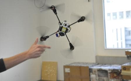
The system built by the Switzerland based university consists of a camera, an inertial measurement unit and a distance sensor all of which captures and send data to an onboard smartphone processor that handles the computation. The computer-vision software built by the researchers analyses the images obtained from the camera for distinctive landmarks that will be used to reconstruct the flight path of the drone. The technology is also able to stabilise the drone in case of rapid winds. The system is clever enough to create 3D maps of the terrain it is flying over to make sure that if needed it can analyse the ground to land by itself. The Swiss researchers have to kind enough to put up their project on <a href="https://rpg.ifi.uzh.ch/software_datasets.html" target="_blank" rel="nofollow noopener noreferrer">Robotics and Perception Group</a> for others to check out.
You can see the results of their efforts in these videos where the team launch a drone by #-Link-Snipped-# and ask it to #-Link-Snipped-#.
Source: <a href="https://rpg.ifi.uzh.ch/aggressive_flight.html" target="_blank" rel="nofollow noopener noreferrer">Robotics and Perception Group</a> via #-Link-Snipped-#
0