India's First Navigation Satellite System To Be Launched On June 12, Shares ISRO

The Indian Government is looking to it that the Indian Space Research Organisation (ISRO) is develops the Indian Regional Navigational Satellite System or the IRNSS to provide two important services. One is the Standard Positioning Service on land, air and water open for civilian use and the Restricted Service, encrypted one, for authorised users. News has it that this Navigation Satellite System-1A, which is India's first, will be launched from the home-grown rocket, PSLV-C22 XL at 1.01 am from Sriharikota Space Port on June 12. Sriharikota is located off the Bay of Bengal on Andhra Pradesh coast, about 90km north-east of Chennai. So, this navigation system, which also helps in disaster and fleet management as well as tracking of vehicles, is a 1425 kg IRNSS-1, with a life span of about ten years.
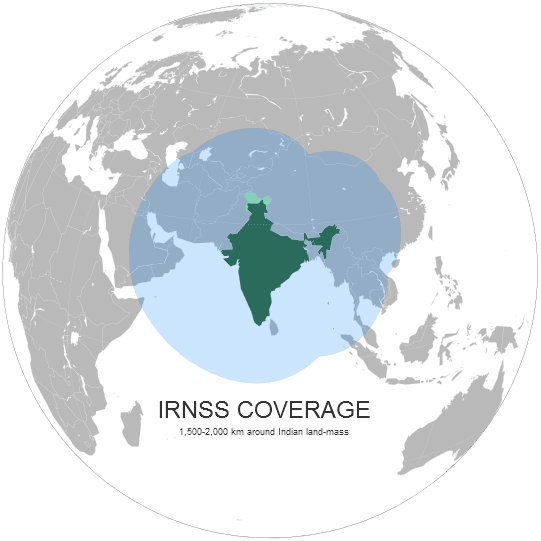
Speaking at a press event, Mr. K Radhakrishnan, Chairman at ISRO based in Bangalore said that, "The IRNSS is designed to provide an accurate real time Position, Navigation and Time (PNT) services to users on a variety of platforms with 24x7 service availability under all weather conditions." So, what do we know and what have we learnt from the event? It is that there will be a constellation of seven satellites under IRNSS by 2014-15. Extending to a region of about 1,500 km around the country, IRNSS is a venture developed at a cost of 16 billion rupees.
After inaugurating a two-day symposium on the 'Saga of Indian Remote Sensing Satellite Programme: 25 years since IRS-1A', Mr. Radhakrishnan said that, "Three satellites will be placed in the geostationary equatorial orbit (GEO) at 34, 83 and 131.5 degree east and two satellites each in the geosynchronous orbit (GSO) with equator crossing at 55 and 111.5 degree east at an inclination of 29 degree." As per wikipedia, the ground segment of IRNSS constellation would consist of a Master Control Center (MCC), ground stations to track and estimate the satellites' orbits and ensure the integrity of the network (IRIM), and additional ground stations to monitor the health of the satellites with the capability of issuing radio commands to the satellites (TT&C stations).
It has also been shared that the the navigation software will be developed indigenously by engineers at the Indian satellite centre in Bangalore. The development of single channel SPS and RS dual frequency receiver is being carried out in house to facilitate the testing of Navigation payload. Also, efforts are being taken to realise the IRNSS Signal Simulator. ISRO is collaborating with NPL to realise a space qualified Rubidium Atomic Frequency Standard. All we have to add is that, we look forward to the launch.
0